

The First Photograph of a Tornado Was Taken in 1884 by a Kansas Fruit Grower
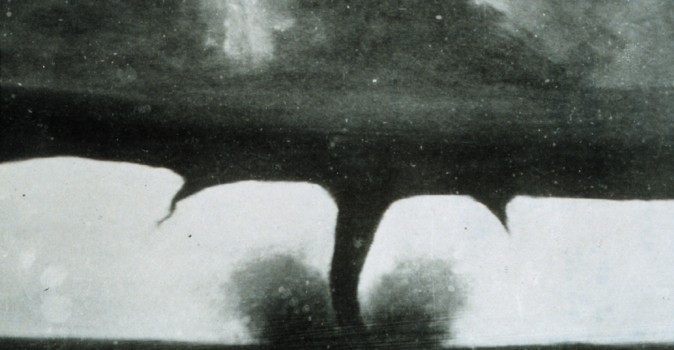
The tornado photograph you have probably seen, the dramatic one with a thick central funnel and two thinner vortices trailing off its side, was probably retouched, its more interesting cloud base likely painted in or combined from another negative. The image that actually came first is far less cinematic: a faint gray thread against a washed-out sky, made on April 26, 1884, by a Kansas fruit grower who happened to still own a camera. It is the oldest surviving photograph of a tornado, and its photographer got it by keeping a heavy camera dead still while a funnel crossed the plains.
The Photograph a Fruit Grower Beat Everyone To
A. A. Adams had moved to Anderson County, Kansas, in 1867 to grow fruit, but before that, he ran a photography studio, and he never got rid of the gear. On the afternoon of April 26, 1884, a tornado formed roughly 14 miles to the west of Garnett, near the hamlet of Westphalia, and started drifting slowly to the northeast. Eyewitnesses said the funnel stayed in view for close to half an hour, which gave Adams time to do something that would have been impossible with a faster storm: haul out his camera, set it up on a corner near the United Presbyterian Church, and expose a plate.
The result is unremarkable to look at. You see a thin rope funnel, slightly bent, hanging under a flat cloud base, with the town in silhouette across the foreground. There is no drama in it. But it reads exactly like what a distant, dying tornado actually looks like, and that ordinariness is part of why historians and meteorologists trust it. It is not a black wedge filling the sky. It is a pale, ambiguous line you have to squint at, and Adams recorded it honestly.
He knew he had something. He printed the image as cabinet cards and stereographs and sold them around town, feeding the parlor-stereoscope craze that was near its peak in the 1880s. By the time he died in 1907, the local paper was crediting him with the first photograph ever taken of a tornado. Prints made from his original negative still sit in the collection of the Kansas Historical Society.
Modern meteorologists have gone back and tested that claim rather than taking it on faith. The date lines up with the era's Signal Corps weather maps, which show a system capable of producing the storm. A Garnett newspaper account describes a funnel that matches the photograph. And a wider, less-cropped version of the image places the Presbyterian Church exactly where it should be, which pins the vantage point to a real spot on a real street. That is a stronger evidence trail than almost any other early tornado picture can offer, and it is why the faint one, not the famous one, tends to get the credit now.
Why You Had to Stand Still to Get It
The shorthand version of this story says Adams wrestled with a wet-plate camera. By 1884, the wet collodion process, which forced a photographer to coat, sensitize, expose, and develop a glass plate while it was still tacky, was already on its way out. Factory-made gelatin dry plates had arrived at the start of the decade, with George Eastman among the manufacturers, and they were a real leap. You could load a plate prepared months earlier and store it after shooting instead of racing a drying chemical bath. Wet collodion was slow enough that exposures were counted in seconds at best, and gelatin dry plates were fast enough that photographers of the period could talk about instantaneous work. How fast in any given frame depended on the plate, the lens, the aperture, the light, and the development, so no single number covers it.
Handheld "detective" cameras existed by the early 1880s, but they were a niche curiosity; there was no mass-market snapshot camera yet in 1884. Eastman would not sell the first Kodak roll-film box, the one that came loaded and shipped back to the factory for developing, until 1888. What Adams used was a tripod-bound plate camera that you focused under a dark cloth, and a clean frame meant the camera could not move and the subject could not move much either. A tornado 14 miles off that stayed in view for half an hour gave him something a closer, faster storm never would: time to see it coming, carry the gear out, set the legs, focus under the cloth, and trip the shutter. The limit was not really the emulsion. It was everything that had to happen before the plate was ready.
The ordinary gelatin emulsions of the day were sensitive mainly to blue light and blind to red, so bright skies tended to wash out to a flat white. That is why the early tornado photographs share a bleached, high-contrast quality, the funnel a dark stroke against a blank field. It was not an artistic choice. It was the film seeing the world differently than your eye did.
That constraint defined the entire first generation of tornado imagery. The funnels that got recorded were the distant, slow, well-lit ones. The violent close-range monsters that define storm photography today were, for years, simply out of reach. Before photography, tornado research depended on eyewitness testimony, sketches, weather observations, and damage surveys, all of which left more room for uncertainty and exaggeration than a verifiable photograph did. A photograph, even a bad one, pinned down real shape and real scale in a way a frightened eyewitness never could.
The Dakota Territory Photo Everyone Remembers
Four months after Adams, on August 28, 1884, a photographer named F. N. Robinson made the image that would hog the credit for the next century. Near Howard, in what was then Dakota Territory, he aimed his camera at a large tornado and captured a black funnel with what look like two smaller vortices spinning off its flanks. It is a spectacular picture. It came from a genuinely violent storm, retrospectively rated F4, and Robinson's possibly altered photograph shows it with two subsidiary funnels. The outbreak it belonged to killed at least six people that day, and some later reconstructions put the toll at seven. Robinson made two exposures and possibly a third, copyrighted the image through the Library of Congress, and sold it as cabinet cards. Two of them survive in the South Dakota State Archives, and one is captioned on the back, "The only cyclone ever photographed was taken by F. N. Robinson, Miner County, D.T. August 28, 1884," which is a fair account of how the misattribution got started. It lives today in NOAA's photo library, and for decades it was reproduced as the first tornado ever photographed.
It is also, by the judgment of the person who has cataloged tornadoes more carefully than anyone, probably not what it appears to be. Thomas P. Grazulis, whose reference work "Significant Tornadoes" is the standard chronology of American tornado history, put it plainly. "This photo was probably touched up or combined with another photograph that had a more interesting cloud base," Grazulis wrote. "Early photographs were frequently altered to make them more saleable commercially."
A dramatic funnel sold cards and a faint gray thread did not, so the market rewarded whoever was willing to paint in a better cloud. Robinson's image beat Adams's in the marketplace for precisely the reason it loses in the archive. The plainer photograph is the more honest one, and honesty was not what nineteenth-century buyers were paying for. The confusion has proven sticky enough that even major outlets have at times listed the wrong image, or the wrong date, as the oldest, so the record is genuinely more tangled than a single clean "first" would suggest.
What Came After the First Frame
The floodgates did not open right away. When Eastman's roll-film Kodak reached the public in 1888, it put a camera in the hands of people who had never focused under a dark cloth, and the number of Americans able to point a lens at a storm jumped overnight. The trouble was that demand for a good tornado picture still outran the supply of real ones. Several celebrated tornado photographs from the end of the century do not survive scrutiny and appear to be composites or outright fabrications, painted funnels dropped into real skies. The clearest case is a pair of images I traced back to the same forged funnel: a tornado at Waynoka, Oklahoma, dated May 17, 1898, and one at Kirksville, Missouri, dated April 27, 1899, both built on a funnel drawn in india ink on glass and printed onto real landscape negatives. The Monthly Weather Review caught it at the time and ran the debunking under the heading "Spurious Tornado Photographs." An image from the Oklahoma City area dated May 12, 1896, credited by the archive that holds it as the first known tornado photograph, sits in that same contested territory, which tells you how muddled the early claims are.
Verifiable storm photography built up slowly through the turn of the century as more plates, and then film, captured funnels that could be cross-checked against damage paths and eyewitness accounts. A 1984 study in the Bulletin of the American Meteorological Society traced some pictures back to their sources, separating the genuine ones from the doctored. Decades earlier, the U. S. Weather Bureau had already begun leaning on photographs for damage assessment, and later, Dr. Tetsuya Fujita would build the intensity scale that still carries his name, a scale rated from the severity of documented damage. Applying that scale retrospectively to reconstructed damage accounts is the only reason a storm from 1884 can be labeled F4 at all, done long after the fact and with an asterisk, since the modern national tornado database that NOAA and the Storm Prediction Center work from only begins later in the 20th century. The Signal Corps and the Weather Bureau documented tornadoes long before that, but not in a form that supports consistent modern ratings.
Modern equipment has erased every limit Adams worked against. Any current weather-sealed body will do in an instant what cost him a tripod, a dark cloth, and half an hour of warning, which means the constraint on tornado photography stopped being technical a long time ago. It is a question of judgment now, and the honest answer is to stay away. Storm chasing kills people, including the most qualified people in the field. Tim Samaras spent his career studying tornadoes and building instruments to place inside them, and on May 31, 2013, the El Reno tornado killed him along with his son Paul and his colleague Carl Young, as well as another amateur chaser, Richard Henderson. It was one of the widest tornados ever recorded, rain-wrapped and moving quickly and erratically, and an intense subvortex hidden inside that circulation looped toward their vehicle. If a funnel is close enough to see, it is close enough to kill you, and the advice has not changed since the Signal Corps was drawing those weather maps: get to shelter, not to a vantage point.
None of that erases what a fruit grower did on a spring afternoon in Garnett. He stood on a street corner, held a wooden camera still, and let a slow gray funnel burn itself onto a sheet of glass. It is a thin, unglamorous picture, and it is the first time a tornado ever sat for a portrait.
Lead image: F. N. Robinson, public domain. Source.
What's Your Reaction?
 Like
0
Like
0
 Dislike
0
Dislike
0
 Love
0
Love
0
 Funny
0
Funny
0
 Wow
0
Wow
0
 Sad
0
Sad
0
 Angry
0
Angry
0









Comments (0)